Traditional urban noise assessments are based on static data (residential exposure, annual maps), without taking daily travel into account. However, our activities (commuting, work, leisure) significantly alter our actual exposure. Thanks to the MobiliSense cohort (289 participants monitored in the Île-de-France region as part of the MobiliSense project coordinated by iPLesp).
Results
Challenges and innovations of the SYMEXPO project: towards healthier and fairer urban mobility
Urbanization and uncontrolled mobility are degrading the quality of life in cities, with noise and pollution levels on the rise. These impacts do not affect everyone in the same way: they vary according to neighborhood, time of day, and social group, thereby exacerbating inequalities. Current assessment methods, based on static data (residential exposure, annual maps), ignore the real dynamics of travel and pollution peaks.
SYMEXPO offers an innovative approach: dynamic models that incorporate daily mobility patterns to accurately assess urban residents' exposure. These tools enable targeted public action and the design of fairer and more effective transport policies.
Why this project ? With increasing urbanization, demand for mobility continues to grow. If poorly planned, this mobility degrades the quality of the urban environment: noise, air pollution, and greenhouse gas emissions intensify, while access to quiet spaces with good air quality is reduced. These impacts do not affect everyone in the same way: they vary according to neighborhood, time of day, and social group, thereby widening inequalities.
To address this, it is crucial to rethink transportation policies in order to preserve the quality of life in cities. This involves gaining a better understanding of how mobility choices influence residents' exposure to pollution and noise, and developing tools to assess the impact of proposed measures (such as multimodal transportation or active mobility).
The limitations of current methods.
Today, environmental impact assessments are often based on simplistic assumptions (reduction in traffic volumes or speeds), without taking into account the actual dynamics of travel and variations in pollution over time and space. The result:
- The calculated exposures do not reflect the reality experienced by city dwellers.
- The models used are static and do not capture pollution peaks or brief but intense exposures.
The SYMEXPO innovation. The SYMEXPO project, funded by the ANR, proposes a systemic approach to assessing the impact of urban mobility on exposure to pollution and noise. Using dynamic models, it represents city dwellers as mobile agents moving around in an environment where pollution levels vary in real time.
Key advances in the project:
- Analysis of mobility behaviors: Data from the MobiliSense cohort made it possible to identify the modes of transportation and activities most exposed to noise (Fancello et al., 2025).
- Development of open-source modeling chains: These tools simulate spatio-temporal variations in noise and air pollution at both the neighborhood and metropolitan levels. Two traffic models were used (SYMUVIA and MATSim), coupled with tools for modeling noise (NoiseModeling) and air pollution (HBEFA/PHEM and SIRANE). These innovative tools were then applied to concrete case studies to assess:
- The impact of exposure to pollution and noise, based on mobility behaviors.
- Socio-spatial inequalities, taking into account individuals' movements to measure access to quiet areas or define critical areas of noise exposure.
Why is this important ? SYMEXPO paves the way for more accurate and fairer assessments of mobility policies by incorporating the temporal dimension and inequalities of exposure. These tools enable decision-makers to design tailored solutions for a healthier, quieter, and more inclusive city.
More details below !
How does travel influence exposure to noise pollution ?
- Why is this important ? Today, individual exposure to noise in cities is often assessed using annual noise maps, which focus on the neighborhood where people live. However, this approach ignores daily travel, which can lead to the actual exposure being underestimated by 10 to 30% depending on the profile.
What we did : As part of SYMEXPO, we analyzed how noise exposure changes over the course of daily activities (commuting, work, leisure). To do this, we used data from the MobiliSense cohort (Chaix et al., 2022):
- 289 participants monitored for 5 days in the Paris region.
- Data collected : GPS, motion sensors, sound level meters, and a detailed questionnaire on their movements.
Our results :
- Actual noise exposure, measured based on mobility behaviors, differs significantly from estimates based on traditional noise maps.
- Underground transportation is associated with the highest noise levels (LAeq often > 70 dB(A)), while exposure at home is generally the lowest.
- Exposure profiles vary : for example, retirees experience a greater proportion of their exposure at home, around 70%.
- These results open up new perspectives for better understanding and modeling noise exposure in urban environments.
Open-source tools for simulating noise and pollution
- A toolkit for cities
To optimize mobility policies while taking into account their environmental impacts, it is essential to have decision-making tools that integrate the spatial and temporal variability of pollution, as well as population movements.
Our tools :
As part of SYMEXPO, we have developed open-source modeling chains to represent the spatial and temporal variations of pollutants (noise and air pollution). These models are based on traffic simulations that integrate the effects of mobility policies on two scales :
* Neighborhood : noise modeling * Metropolitan area : noise modeling
(microscopic traffic simulation) (agent-based simulation)
* Neighborhood : air pollution modeling * Metropolitan area : air pollution modeling
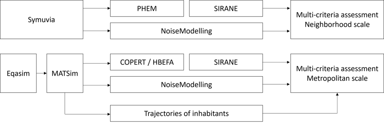
- SYMUVIA is an open-source platform for microscopic traffic simulation. It generates vehicle trajectories with a resolution of one second. Route choices are determined by a dynamic traffic assignment model, which guides each vehicle toward the route that minimizes its travel time. Vehicle movements are modeled at the microscopic level, taking into account vehicle tracking rules, lane changes, and intersection crossings.
- MATSim is an open-source, agent-based, large-scale transportation simulation framework. It enables dynamic exposure calculations at the individual level. This “individual-centered” approach simulates the behavior of a synthetic population that is representative of the real population. Each agent is associated with a socio-economic profile (based on census data) and a daily schedule that includes work and leisure activities.
- NoiseModeling is an open-source noise prediction tool that implements the European CNOSSOS method, defined by Directive 2015/996 on the assessment and management of environmental noise.
- COPERT and HBEFA are widely used open-source software programs for calculating air pollutant emissions from road transport.
- SIRANE is an urban air pollution model designed for scales ranging from neighborhoods to metropolitan areas. It provides spatial and temporal evolution of pollutant concentrations in urban environments, in the form of maps or time series. The model takes into account key dispersion processes in the urban canopy and the atmospheric layer above rooftops, as well as certain physicochemical processes.
Open-source modeling chains developed in the SYMEXPO project
To ensure the reproducibility of results and encourage improvements by the scientific community, these modeling chains are accessible via dedicated GitHub repositories:
Further details are available in specialized articles. (Le Bescond et al., 2021 ; Le Bescond et al., 2023 ; Hankach et al., 2024 ; Tirico et al., 2025b).
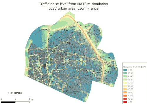
Case studies: critical noise exposure areas (Lyon)
A method for improving the estimation of critical noise exposure areas:
Traditional urban noise assessments are based on residential exposure, ignoring daily commutes. In Lyon, we cross-referenced mobility and noise levels to identify areas where exposure exceeds 65 dB(A) over 15-minute intervals. The result: we found that 10% of critical noise exposure areas are not taken into account if mobility is not considered. Schools and public places appear to be priorities for reducing noise pollution.
")
Identifying urban areas with high levels of noise exposure is a key step in developing effective action plans and protecting public health. The standard European assessments used to guide this identification process are based primarily on residential noise exposure, without taking daily mobility into account.
In the work of Galassi Luquezi et al. (2025 and 2025c), the open-source modeling chain for estimating noise exposure based on MATSim, developed as part of the SYMEXPO project, was used to refine this identification. This approach takes into account the mobility and daily activities of the population, thus allowing for better targeting of critical areas.
An innovative approach to defining critical exposures This method allows two time horizons to be distinguished in the assessment of critical exposures. Two indicators were calculated on 200-meter cells in the study area :
- The first indicator identifies critical short-term exposures, defined as exposure doses exceeding 65 dB(A) over 15-minute intervals (LAeq,15mn >= 65 dB(A)).
- The second indicator quantifies the number of critical short-term exposures among individuals already subject to high medium-term exposure (LAeq,15min >= 65 dB(A) for agents whose exposure between 6:00 a.m. and 10:00 p.m. is >= 65 dB(A)).
Revealing results : The work of Galassi Luquezi et al. (2025) shows that not taking mobility into account leads to a 10% underestimation of critical exposure occurrences in the study area. For targeted actions, the diversity of population characteristics can help prioritize reduction efforts. For example, the study reveals that reducing exposure in educational settings could cut critical exposures among young people by nearly half.
An initial mitigation initiative could therefore focus on these educational exposures, which are more spatially localized than critical exposures linked to other activities. Furthermore, this approach highlights the fact that regulatory values do not always reflect local daily rhythms. For example, the definition of the evening period, currently marked by a 5 dB penalty in environmental acoustics for exposures between 6 p.m. and 10 p.m., could be adjusted to better correspond to the actual times at which individuals return home.
These indicators were applied to the case study of the Lyon metropolitan area, as illustrated above.
Case studies: Impact of urban construction sites on noise (Champigny-sur-Marne)
A modeling framework to optimize construction site management : Construction sites generate noise pollution that affects local residents. In Champigny-sur-Marne, we simulated the impact of a construction site on 1.3 million residents by measuring the number of “quarter-hour people” exposed to more than 65 dB(A) due to the construction site (i.e., not counting people already exposed to 65 dB(A) due to road traffic). The result : 3,300 critical exposures related to the construction site. The solution ? Shift work to off-peak hours or when ambient noise is already high.
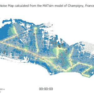
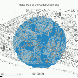
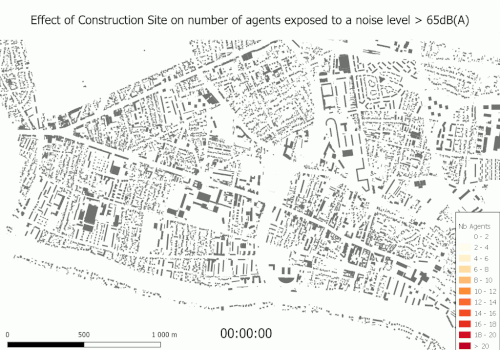
In a study conducted by Hankach et al. (2024), the open-source modeling chain based on MATSim, developed as part of the SYMEXPO project, was used to dynamically assess the acoustic impact of construction sites. This approach proposes indicators based on 15-minute resolution noise maps, combining both construction site and road traffic noise, as well as individuals' trajectories over the same time intervals.
A key indicator was defined: the number of individuals exposed, in 15-minute intervals, to noise levels exceeding 65 dB(A) due to the construction site, excluding those already exposed to 65 dB(A) from road traffic. This indicator, inspired by the work of Nygren et al. (2024), can be calculated for the entire population or for specific demographic categories.
To illustrate the relevance of this methodology, a case study was conducted in Champigny-sur-Marne (France), involving the generation of a synthetic population of more than 1.3 million individuals. The results revealed that more than 3,300 “quarter-hour people” were exposed to noise levels above 65 dB(A) due to the construction site (see below).
This approach optimizes construction site management scenarios by aligning the noisiest periods with times of low traffic or when ambient noise levels are already high.
Case study: Access to quiet zones (Lyon)
Quiet green spaces (less than 50 dB(A)) are essential for health. In Lyon, we analyzed access to these areas during the lunch break (12 p.m.–2 p.m.), taking into account people's mobility. The result : only 30% of Lyon residents currently have access to them, but this figure could reach 85% if all green spaces were protected from noise. Inner courtyards and riverbanks are the most accessible.
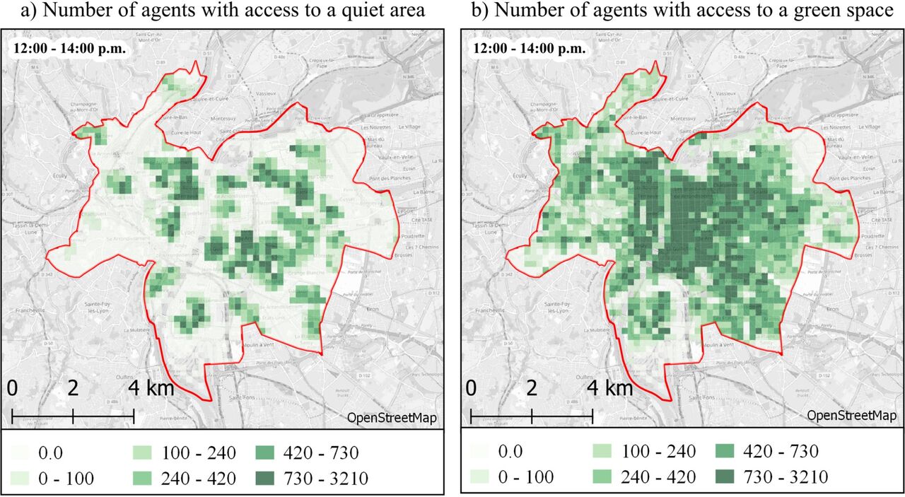
The health benefits of quiet, natural spaces are widely recognized. Access to these areas is therefore an essential element in urban noise reduction strategies. While traditional methods evaluate this access statically, a recent study by Galassi Luquezi et al. (2025b) proposes a dynamic approach, based on individual behavior, to measure access to quiet and green areas at the city level. This methodology uses the MATSim transportation model to simulate individual travel and noise levels at 15-minute intervals, incorporating principles of temporal geography to capture variations in urban environmental opportunities over time.
The study focuses on the Lyon metropolitan area (58 municipalities, 1.4 million inhabitants, 533.7 km²) and analyzes access to quiet areas during the lunch break (12:00 p.m.–2:00 p.m.). Quiet areas are defined as green spaces where noise levels remain below 50 dB(A) over 15-minute intervals. Access is measured by a maximum walking distance of 375 meters to the nearest quiet area. Two key indicators are proposed to guide decisions:
- The ratio of access to quiet areas: proportion of individuals with access to a quiet area compared to those with access to a green space.
- The ratio of quiet area surface area: percentage of green spaces that meet the criterion of tranquility.
This approach allows green spaces to be classified according to their attractiveness, i.e., the number of individuals who currently have access to them or their potential for access. The results show that nearly 30% of individuals have access to at least one green and quiet area in the study area. However, if all green spaces were quiet, this figure could reach 85%.
These data highlight the importance of preserving existing public, open, and green spaces. Courtyards and green spaces along riverbanks are identified as quiet and highly accessible areas. Finally, small parks and squares located near busy urban centers offer the greatest potential for improving access to quiet areas.
This study demonstrates the value of dynamic, individual-based models for assessing and improving urban environmental quality, providing useful information for urban planners and public health decision-makers.
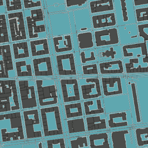
Case study: Multi-criteria assessment of pollution around schools (Lyon)
How can we protect children from pollution? Two scenarios were tested around schools: access restrictions vs. speed reduction. The results showed that restrictions significantly reduce noise and pollution, while speed reduction has a limited effect (and may even increase pollution, as vehicles drive more slowly). The tools developed help to choose the most effective measures for sensitive areas.
The neighborhood-scale modeling chain developed as part of the SYMEXPO project enables multi-criteria assessments that incorporate noise and air pollution impacts. This modeling chain, which is based on a microscopic traffic model such as SYMUVIA, offers several advantages:
- The sensitivity of the traffic model to traffic conditions, such as the spread of traffic jams or the reallocation of traffic flows, which makes it possible to study detailed scenarios, such as speed reductions.
- It allows for more accurate estimates of air pollutant emissions or specific acoustic indicators such as noise peaks.
A case study focusing on schools
A recent study (Tirico et al., 2025b) used this tool to evaluate different solutions aimed at reducing pollution and noise around schools. Several scenarios were tested, such as access restrictions to limit traffic around schools and speed reductions to calm traffic and reduce pollution.
The results show that, in the context of this case study, access restrictions significantly reduce noise and air pollution. On the other hand, speed reduction scenarios have more nuanced effects: their impact on noise remains limited, while they can lead to an increase in air pollution due to vehicles traveling at low speeds in the area concerned.
This study demonstrates that a comprehensive assessment framework, incorporating temporal, spatial, and multi-zone analyses, is essential to fully understand the effects and trade-offs of traffic management strategies.
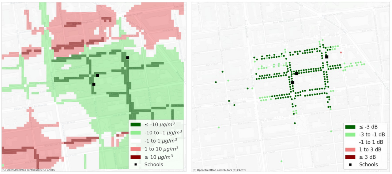
Impact of a capacity restriction at the edges of three schools on noise, PM10 (left) and noise (right)
Impact of capacity restrictions near three schools on noise, air pollution, and traffic flow